


Trans Canada Trail Explorer app for iPhone and iPad
Developer: Johnson Outdoors Canada, Inc.
First release : 30 May 2015
App size: 8.2 Mb
Trans Canada Trail Explorer
Plan, track, and log your hikes on the Trans Canada Trail, one of the worlds longest networks of multi-use recreational trails.
Carry the most up-to-date Trans Canada Trail information with you on your day-hikes or long-distance adventures.
This is an unofficial Trans Canada Trail App. For official and up to date TCT information, please go to http://tctrail.ca/
Features:
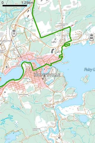
=> The Entire Established Trail:
To date, nearly 17,000 kilometres of the Trail are operational which is 75 percent of the proposed route and all of this established trail is available in the App. Tap on any trail segment to see its name.
=> Photo Sharing:
Take photos and see them plotted on the trail. Share photos with Facebook, Twitter, Tumblr, iMessage, email, and more.
=> Background Map Options:
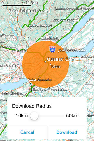
Switch between the official Canadian Government relief maps, topo maps and Apple(TM) Maps satellite photo views; Turn street maps on and off. Download Canadian Government relief maps and topo maps directly to your iOS device for offline use when out of cell or WiFi coverage.
=> Measure the Trail:
Tap along the trail to plan your route and measure the distance you will be hiking or paddling. See a dynamic scale bar on the map.
=> Record Tracks:
Record your days hike or paddle as a track file and see how far you have traveled. Leave the GPS on as a background task to record your track while you use other Apps or lock the screen. WARNING: Continued use of GPS running in the background can dramatically decrease battery life.
=> Map Pans as You Move:
Track your location with a map that moves as you move. Set the map to keep north up or to rotate with your direction of travel.
=> Download Maps for Offline Use:
When you have cellular or Wi-Fi access, download the background topo maps for your selected region. You can be certain all the data you need is on your iOS device when you head out on the trail without internet access.
=> Find Place Names, Restaurants, Stores, Gas stations and Other Services:
With the built-in Apple(TM) Maps search (while in cell of WiFi coverage), quickly locate the services you need within easy access of the trail.
___________________________________
About the Trans Canada Trail:
Initiated in 1992 as a project to celebrate Canada’s 125th year, the Trans Canada Trail, once fully connected, will stretch nearly 24,000 kilometres from the Atlantic to the Pacific to the Arctic oceans, through every province and territory, linking Canadians in nearly 1,000 communities. The Trans Canada Trail is made up of nearly 500 individual trails, each with unique and varied features. This contributes to the diversity and grandeur of Canada’s national Trail. For day trips or multi-day adventures, the Trail offers countless opportunities to explore and discover.
This is an unofficial Trans Canada Trail App. For official and up to date TCT information, please go to http://tctrail.ca/